
On November 7, 1996, a McDonnell Douglas Delta II 7925 rocket lifted off from Cape Canaveral carrying NASA’s Mars Global Surveyor — the agency’s first successful Mars mission in nearly two decades. The spacecraft was built to map a planet scientists believed was essentially finished. What it found suggested Mars had barely begun to give up its secrets.
A 20-Year Gap and a High-Stakes Comeback
The launch carried unusual institutional weight. NASA’s last successful Mars orbiter, Viking, had operated in the late 1970s. In the intervening years, the agency had watched missions fail and budgets contract, and Mars had come to feel less like a destination than a graveyard for spacecraft and ambitions.
Officials were careful to frame the mission not as a single attempt but as the opening move in a sustained program of exploration — a phrase that carried real weight after years of stops and starts. Another high-profile failure at Mars risked draining political support from the entire planetary science enterprise, not just one mission. What launched that November was as much a demonstration of renewed institutional resolve as it was a scientific expedition.
What the Spacecraft Was Built to Do
Mars Global Surveyor was an orbiter — not a lander, not a rover. Its job was to circle Mars methodically and build the most detailed maps of the planet ever attempted. The name was straightforwardly literal: survey the entire globe, instrument by instrument, pass by pass.
To accomplish that, the spacecraft carried a precisely chosen suite of tools. A laser altimeter would measure surface elevation with unprecedented precision. A thermal emission spectrometer would identify minerals by the infrared light they radiated. A magnetometer would probe the planet’s magnetic environment. Each instrument targeted a different layer of Martian reality, from the deep crust to the thin upper atmosphere.
After roughly ten months of travel, the spacecraft entered orbit around Mars in September 1997. NASA’s first Mars mission in nearly 20 years had arrived and was ready to work. What followed would systematically dismantle the scientific consensus about what kind of planet Mars actually was.
A Planet That Was Supposed to Be Simple
The prevailing scientific picture going into the mission was clear enough: Mars was a geologically dead world, frozen in time, its surface a passive record of ancient impacts and accumulated dust. The planet had no detectable global magnetic field, no signs of active plate tectonics, and an atmosphere so thin it barely qualified as one. Every available indicator pointed to a planet that had exhausted itself billions of years ago and had been slowly eroding ever since.
The mapping goals were ambitious, but the science was expected to be more confirmatory than revelatory. Researchers anticipated filling in the details of a story they believed they already understood. That assumption would not survive contact with the data.
The Magnetic Field Discovery That Rewrote Martian History

Among the most consequential findings from the entire mission was something the magnetometer detected in the southern highlands: stripes of magnetized rock locked into the ancient crust. These magnetic signatures were evidence that Mars once possessed an active global magnetic field — one that functioned much like Earth’s before the planet’s core cooled and the field collapsed billions of years ago.
The striped pattern was striking for an additional reason. It echoed the seafloor spreading signatures that geologists observe on Earth, where new crust forms at mid-ocean ridges and records the prevailing magnetic field as it solidifies. The implication was significant: Mars may once have experienced a form of tectonic activity, something scientists had not seriously entertained before.
This discovery did not simply add a data point. It fundamentally altered how researchers think about early Mars, raising the possibility that the planet was once far more Earth-like than its current frozen, airless state suggests. A functioning magnetic field would have shielded an early Martian atmosphere from solar wind erosion, potentially allowing liquid water to persist at the surface for geologically meaningful stretches of time.
A Surface Full of Surprises
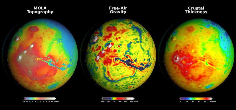
The laser altimeter produced the first true three-dimensional topographic map of Mars, and the results immediately raised new questions. The planet’s northern and southern hemispheres differ in average elevation by several kilometers — a stark divide that planetary scientists still actively debate. The northern plains sit dramatically lower than the ancient, heavily cratered southern highlands, and no fully agreed-upon explanation has emerged for why.
The spacecraft’s camera system returned images of gullies carved into crater walls that looked geologically recent — far too young to have formed billions of years ago. The implication was uncomfortable and exciting in equal measure: liquid water may have moved across the Martian surface far more recently than the dead-planet model allowed.
Perhaps the most operationally consequential surface finding came from the thermal emission spectrometer, which identified deposits of crystalline hematite concentrated in a region called Terra Meridiani. On Earth, hematite of that type typically forms in the presence of liquid water. The detection was specific enough to serve as a landing site recommendation — and when NASA’s Mars Opportunity rover eventually reached that exact location, it found hematite-rich spherules that confirmed the watery history the spectrometer had suggested.
Taken together, these findings replaced the portrait of a simple, static world with something far more complicated: a planet with a layered history in which water had played a central and recurring role.
A Mission That Refused to End
Mars Global Surveyor was planned for a primary mission lasting one Martian year — roughly two Earth years. It operated for nearly a decade. Rather than retiring when its core mapping work was complete, the spacecraft wove itself into NASA’s expanding Mars infrastructure, serving as a communications relay for later landers and continuing to return new science data throughout.
When the spacecraft finally fell silent in November 2006 following a battery failure linked to a software command error, it had transmitted more than 240,000 images and contributed foundational data to virtually every discipline within Mars science. The mission reshaped the field across nearly a decade of continuous operation, far outlasting what anyone had originally planned.
Why November 7, 1996 Still Matters
The launch of Mars Global Surveyor marked the moment NASA stopped treating Mars as a destination it visited occasionally and started treating it as a place it was genuinely committed to understanding over the long term. Every mission that followed — from the Mars Pathfinder lander that arrived the following year to the Perseverance rover operating on the surface today — built on the geological, atmospheric, and topographic framework that the surveyor established.
The mission also demonstrated something methodological that proved durable: an orbiter carrying the right instruments, operated patiently and systematically, could produce transformative science rather than mere reconnaissance. That lesson shaped Mars mission design for the decades that followed.
And then there was the finding that cut deepest. NASA launched Mars Global Surveyor to map a dead planet. The planet it mapped turned out to have once harbored a global magnetic field, possible tectonic activity, liquid water, and mineral chemistry that on Earth accompanies biological processes. Scientists sent the spacecraft to confirm what they already knew. Mars, as it turned out, had other plans.